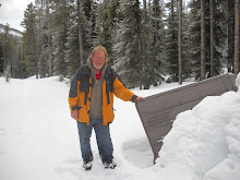
On November 3, 2008 I picked up Ken and we drove to Waterton Park. It was my intent to attempt a hike up to Forum lake and even perhaps as far as the Tri-Boundary marker. But when we arrived in Waterton we found the road to Cameron Lake was closed. After considering our options we settled on hiking from Cameron Falls to Carthew Lake. Therefore, another attempt to hike to Forum Lake was unsuccessful.
Here are the statistics of the hike:
Distance hiked, note this is to Carthew Lake only, not there and back, My GPS showed 10.97 km (not accurate), Topo Map shows 7.25 km (this seems not far enough), Mapsource Map shows 9.5 km (I think this is the most accurate). The total distance would have been about 19 km.
Time to hike in 3 hr. 11 min. moving 1 hr 39 min stopped time. Total 4 hr 50 min. I estimate that it took about 3 hrs to hike out. So the total time hiking would have been 6 hrs 20 min.
Moving average, in only, 3.4 km/hr.
The GPS shows the elevation difference was 3168 ft but the map shows it as 2800 ft. The map is more accurate.
Friday, December 26, 2008
Subscribe to:
Post Comments (Atom)

No comments:
Post a Comment