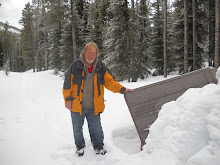

The highest that I could go on this hike was 8100 feet on a wide portion of the Akamina Ridge. An accommodating passing hiker took my photo on this ridge. I think that 8100 feet is the highest that I have been since I have started keeping track. This is certainly the highest that I have been this year. I think of the book Eat Pray Love, where the author meditates on a roof and how much closer she feels to God there. One cannot help but feel very connected to the Universe when one is standing on a high place. The hiker that I met and who took my picture told me that people ski to the Three Boundary Marker. This placed in my mind another possible way of some day reaching the Three Boundary Marker. Or I am thinking that perhaps this epic hike of mine actually started in July 2007 when my son and I canoed across the Canada - USA border on Cameron Lake.
There is no clear trail off this ridge and a hiker needs to be aware of the surroundings to navigate back to the trail. There is a fantastic view of both Forum Lake and Wall Lake from this ridge. A couple of hundred metres or more along the ridge between Forum Lake and Wall Lake there are cairns marking the trail. Once the trail comes to where I had to start my scramble down over the rocks it became very diffused. Since there was no clear path to follow, and I had to pick my way down, this is rather tedious and was slow going for me. The scramble seemed to go on for a long time but I did finally make it to the trail back to Forum Lake, where I had just been a couple of weeks before.
It wasn't long until I was back into the mosquitoes. I met maybe two parties of hikers on my way out so for the most part I had the trail to myself.
As I was walking out on the Akamia Pass trail I noticed some movement along the edge of the trail and just into the bush. I didn't see what it was but it was bigger than a bird or a ground squirrel. I slowed my pace and tried to peer into the bush. I could see the brush moving so I knew there was something in there. I was peering intently into the brush and moving very slowly when a I saw the head of a Blackbear. She was only feet away from me and she was as startled as I was. Fortunately she bounded away from me through the trees with her cub in tow. That gave me quite a start and I remembered, too late, that I should be making more noise as I walk.
What an exhilarating hike!
Total distance hiked was about 13 km. Moving time was 5 hours 24 min, stopped time was 2 hours39 min. My GPS showed the total ascent at 3035 feet but my starting elevation was 5513 ft. and my maximum elevation was 8100 ft. so that is only a net ascent of 2587 ft.

No comments:
Post a Comment